Hello everyone, we are happy to share good news!!!!
We have signed an alliance with tour operators in Quito, therefore from now
on we will offer high level tourist services in Quito and surroundings.
http://www.guayaquilaguidedvisit.com/
http://www.guayaquilaguidedvisit.com/
A RARELY seen, (even frequent visitors don´t get to see them in years!!) but we got to see a CONDOR flying quite close from us!!!
And it is that a quick description of the mountainous area of Ecuador
would be the following: a so-called "Avenue of the Volcanoes" is a
scenic route that goes along the Ecuadorian Sierra having as main peaks West of
Quito EL PICHINCHA (Guagua & Ruco:
Baby/Young and Old) , towards the south of Quito on the way to the
Cotopaxi National Park, home of the snow-covered volcano Cotopaxi, with its
almost perfect cone, we see wonders such as the PASOCHOA, the RUMIÑAHUI, the
HEART, the ILLINIZAS the INTISANA and
further south the TUNGURAHUA, the CHIMBORAZO and the ALTAR.
The central part of the Ecuadorian Highliands is beautiful and is ideal for
lovers of hiking and mountaineering.
In 1812, the German scientist Alexander Von Humboldt called it
the Avenue of the Volcanoes since there are more than 70 mountains,
27 of them still active, along 300 kilometers of the Ecuadorian Andes,
which can be traversed by the Pan-American Highway from north to south
and contemplate the landscapes
A more detailed list would be the following:
Most of the highest mountains in Ecuador are on “Avenida de los Volcanes”.
The avenue of the Volcanoes
The avenue of the Volcanoes
Chimborazo - 6,268 meters (20,702 feet)
Cotopaxi - 5,897 meters (19,347 feet)
Cayambe - 5,790 meters (18,996 feet)
Antisana - 5,704 meters (18 713 feet)
The Altar - 5,320 meters (17,244 feet)
Illiniza Sur - 5,263 meters (17,267 feet)
Sangay - 5,230 meters (17,158 feet)
Carihuairazo - 5,020 meters (16 469 feet)
Tungurahua - 5,016 meters (16,456 feet)
Cotacachi - 4,939 meters (16,204 feet)
Sincholagua - 4,898 meters (16,070 feet)
Imbabura - 4,609 meters (15,121 feet)
Guagua Pichincha - 4,776 meters (15,670 feet)
Rucu Pichincha - 4,627 meters (15,180 feet)


Illiniza is a stratovolcano in Ecuador, located about 100 km southwest of Quito.
Illiniza, a potentially active volcano, consists of two snow-covered peaks:
Illiniza Sur (5,248 m) and Illiniza Norte (5,126 m).
Its name derives from the words kunza for «hill male».Whilst Illiniza South (the southern peak) is a more difficult climb due to its glacial nature,Illiniza North requires little or no climbing expertise, and may be climbed as a trekking peak.A guide is always recommended, however, as the path becomes hard to navigate asit approaches the summit.http://www.guayaquilaguidedvisit.com/The Illinizas are excellent mountains for acclimating to altitude, and are frequently used asa preparatory climb to higher peaks such as Cotopaxi, Chimborazo and Cayambe.There is a rustic refuge located between the north and south peaks.It can be reached in one hour by car from El Chaupi.The Englishman Edward Whymper tried and failed twice to make the first ascent ofIliniza Sur. It was climbed for the first time in 1880 by his two Italian guidesJean-Antoine Carrel and Louis Carrel. The first ascent of Iliniza Norte was made in 1912by the Ecuadorians Nicolás Martínez and Alejandro Villavicencio.

But again today´s main focus is:
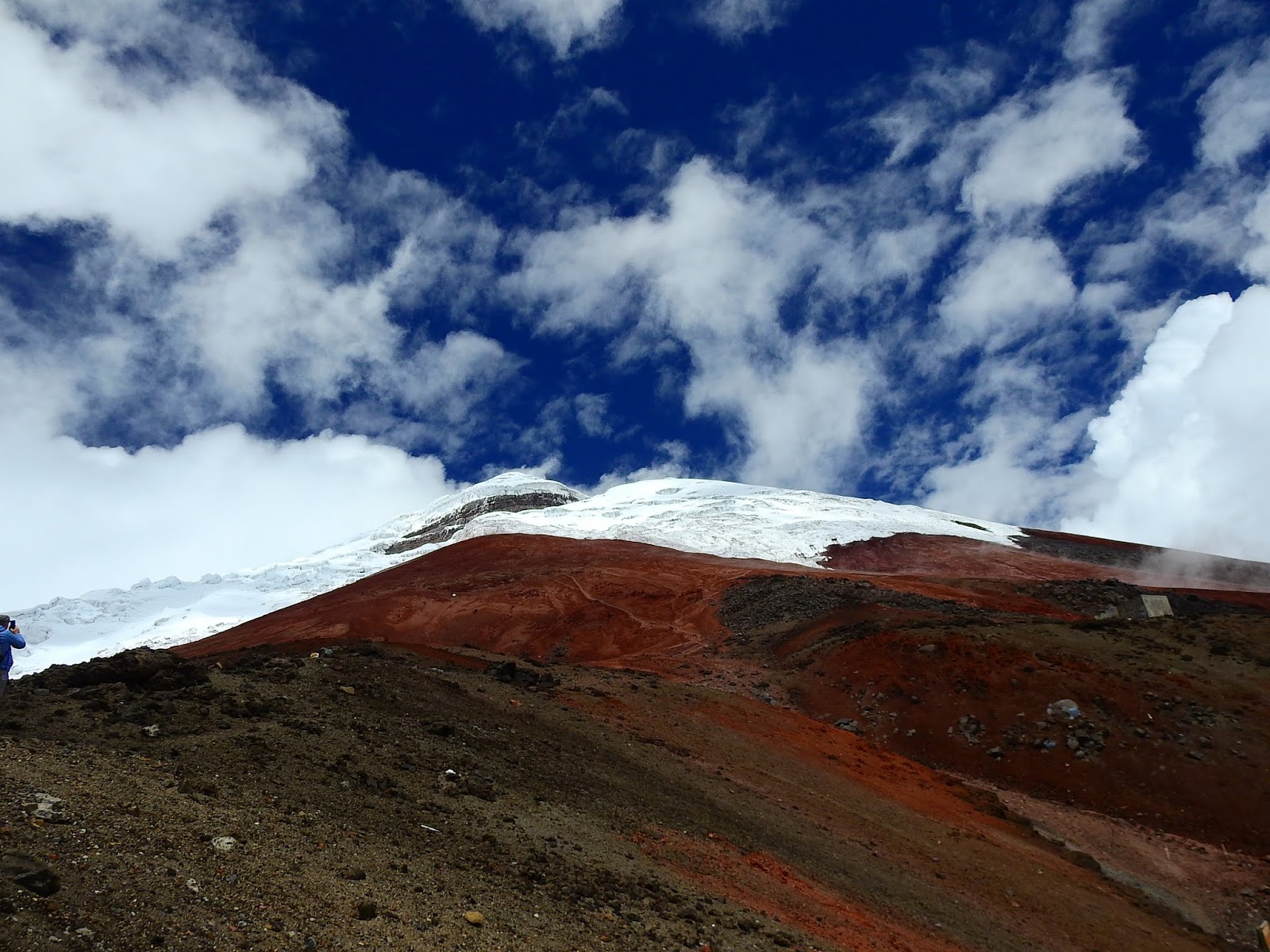
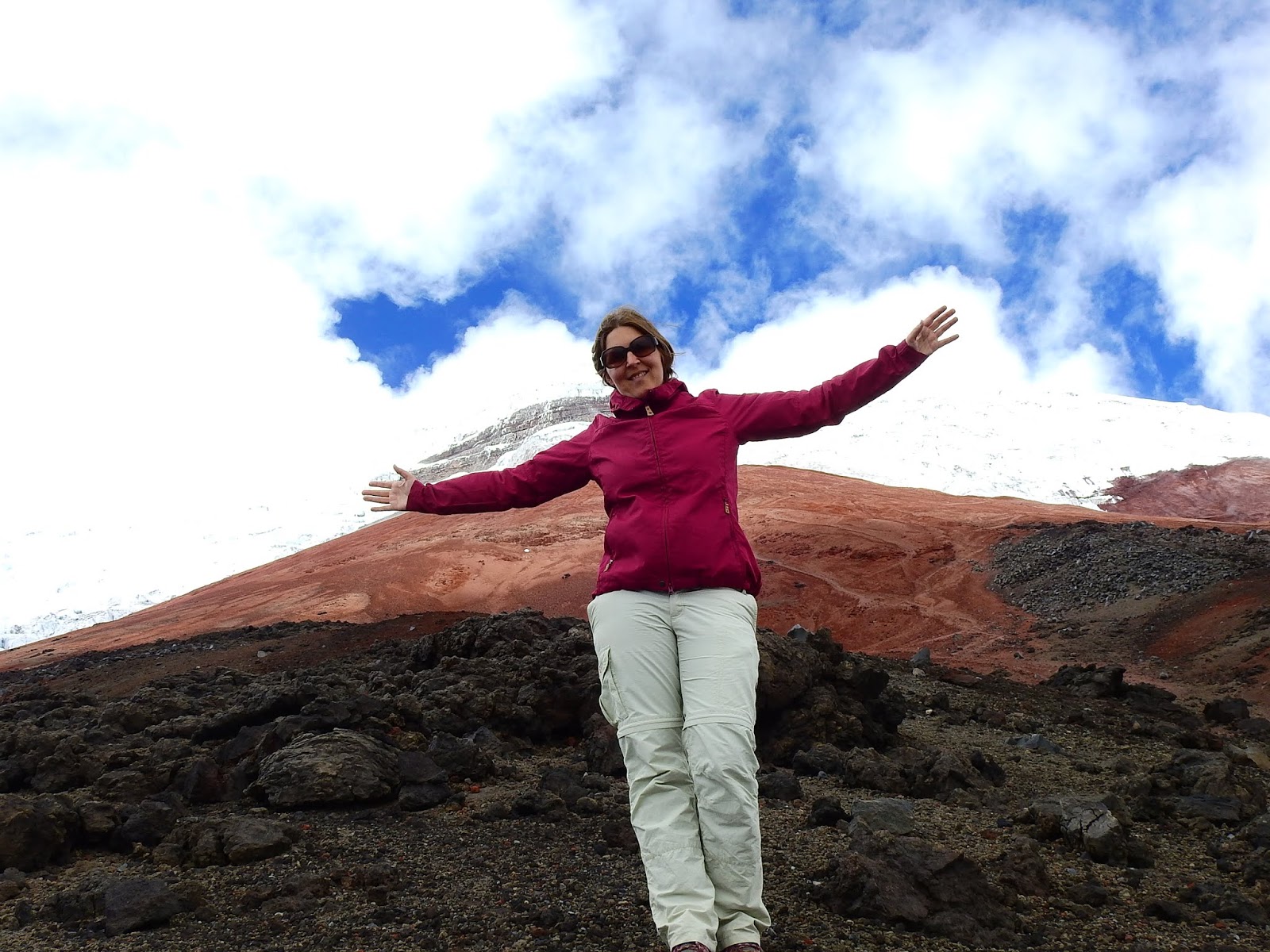
Cotopaxi One of the highest active volcanoes in the world.

Cotopaxi is an active stratovolcano in the ecuadorian Andes located 50 km (31 mi) south of Quito, It is the second highest mountain in Ecuador, reaching a height of 5,897 m (19,347 ft). It is one of the world's highest volcanoes.Since 1738, Cotopaxi has erupted more than 50 times, resulting in the creation of numerous valleys formed by lahars (mudflows)
around the volcano.
The last eruption lasted from August 2015 to January 2016.Cotopaxi had been
officially closed for climbing by authorities until it reopened on October 7, 2017.NameMany sources claim that Cotopaxi means shining pile or mountain in an indigenous language, but this is unproven.
There is also the Quichua translation to: “Neck of the moon” since on a clear
evening if the watcher is seated on the western plateau he/she will see the
moonrising and it seems to be ascending from the volcano´s crater.The mountain was honored as a "Sacred Mountain" by local Andean people,
even before the Inca invasion in the 15th century. It was worshiped as “rain sender”,
that served as the provider of the land's fertility, and at the same time its summit was
revered as a place where gods lived.We offer biking tours at Cotopaxi!!!

http://www.guayaquilaguidedvisit.com/
Historic EruptionsWith almost 90 known eruptions, Cotopaxi is one of Ecuador's most active volcanoes.
The first recorded eruption of Cotopaxi was in 1534.Cotopaxi's most violent eruptions in historical times occurred in the years
1742, 1744, 1768, and 1877.The 1744 and 1768 events destroyed the colonial town of Latacunga
In June 26th 1877 eruption, pyroclastic flows descended all sides of the mountain
melting the entire ice cap, with mud flows traveling more than 100 km into the
Pacific ocean and due west into the Amazon basin draining the valley.The city of Latacunga was again leveled completely due to the mudslide deposits.The eruption on June 19th 1742 was witnessed by the scientists
Pierre Bouguer and Charles M. de La Condamine members of the French Geodesic
Mission as they descended from nearby Volcano, Guagua PichinchaThere was a major eruption from 1903 to 1904, and minor activity persisted until at least
1940 and possibly 1942.There has been an increased thermal/seismic, non-eruptive activity in 1975 and 2002. In the increased activity of 2002, fumaroles activityand sulfuric emissions
increased and ice around the inside and on thesoutheastern side of the cone
started to melt. However, no actual eruption was observed.In 2015, two large phreatic (steam) eruptions in the morning of the 14th of August
marked a new phase of volcanic activity.
The volcano remains in a very abnormal situation.In August, 2,100 earthquakes were recorded and emission rates of sulfur dioxide
reach approximately 20,000 tonnes per day".
The government estimates some 300,000 people are at risk from the volcano in the
provinces of Cotopaxi, Tungurahua, Napo and Pichincha.http://www.guayaquilaguidedvisit.com/ClimbingThe first European who tried to climb the mountain was Alexander Von Humboldt in 1802, however, he only reached a height of about 4500 m. In 1858 Moritz Wagner investigated the mountain, but he could not reach the summit either.On November 28, 1872, German geologist Wilhelm Reiss and his Colombian partner Angel Escobar finally reached the summit of CotopaxiRecreationClimbing Cotopaxi to the summit is quite popular with up to 100 climbers attempting it on
weekends.Today, mountain guide companies offer regular guided climbs of the mountain and as of
11 December 2012 — no mountain peaks in Ecuador over 5,000 m high may be climbed
without a licensed guide.


Climbers grade the conventional
route alpine PD (Peu Difficile) or
WS (Wenig Schwierig) or PD/WS+
(indicating "Mildly Difficult PLUS").http://www.guayaquilaguidedvisit.com/book-online/Use of crampons and ice axes are mandatory as snow and ice slopes of up to 50 degrees are encountered and climbers should be on belay and
use aluminum ladders to cross one or two of the crevasses. A 4WD track goes up
from the national park entrance to a carpark at 4600 m altitude on north side,
just below the José F. Ribas Refuge.This stone mountain hut — owned and operated by Grupo de Ascensionismo
Colegio San Gabriel is situated 200 m higher at 4800 m (a 40-80 minute uphill hike).
Here climbers can spend the night and begin their summit bid in the early morning without
any intermediate camps. (Typically no more than about half of those attempting to summit
Cotopaxi make it to the top after a daunting though non-technical six-hour scramble.)Summiting normally starts around 12:30 am to reach the summit at latest 7:30 am
and then return to the hut before the snow melts and glacier crevasses move/evolve.LocationThe Cotopaxi is located in the central chain of mountains of the Ecuadorian Andes 62 kmnortheast of Latacunga and 75 Km southeast of QuitoLimits: To the northeast the extinct volcano Sincholagua, and the Rumiñahuito the west. The Quilindaña to the SoutheastAltitudeCotopaxi is one of the highest volcanos in the world with 5943 m. n. m.It has been calculated that the width of its crater from east to west measures 500 mand from north to south about 700 m.WeatherThe climate presents a variety and contrast typical of the effects of altitude and orientation.http://www.guayaquilaguidedvisit.com/book-online/BiodiversityA large pine plantation covering approximately 1750 ha, chuquirahuas, pumamaquis,romerillo, mortiño and capulí, are just some of the species that can be found.As regards fauna, curiquingues, deer, rabbits, páramo wolves andthe rarely seen Andean condor, they can appear at any time.http://www.guayaquilaguidedvisit.com/book-online/Attractions• Sunfana viewpoint: From there you can see vast pine forests on the Sunfana Plain,at the foot of the viewpoint. You can walk there in about 30 minutes fromthe Administrative Center or by vehicle; There is a place to camp there and if you followthe path for about two hours you will arrive at the foot of the Rumiñahui volcano.• Andinism, the Cotopaxi volcano has an exotic dry micro climate that allows its ascentduring most of the year. Starting at 4800 meters and in an approximate time of 6 to 8 hours,you can reach the foot of the impressive crater half a kilometer wide and be ecstatic withthe spectacular view of the tops of most volcanoes in Ecuador.Technically it is not complicated to crown, however a guide will be of great help in case ofbeing a rookie.• Lakes: Scenically attractive, the lagoons are located to the southeast of the Park,about three kilometers from the Mauca-Mudadero control.• Quishuar Trail: On the way you pass through most of the attractions in the area,always through the pine forest.• Laguna de Santo Domingo: It is presented as an interesting landscape.Next to the spring that supplies it there are vestiges of quadrangular form of stone wallsprobably of Inca origin.LegendThe Cotopaxi, for several centuries, was a place of worship for the native Quichua.History tells that, inthe year 1534 during a bloody combat against the spanish forcesthe Cotopaxi unleashed its fury with a sudden eruptionThe Spanish troops fled in terror, while the natives prostrated themselves on the groundand began to worship “him”.On our way from Quito to the Cotopaxi we will actually see many other mountianssuch as: Pichincha, Illinizas, Pasochoa, Corazón, Rumiñahui.http://www.guayaquilaguidedvisit.com/book-online/El Pasochoa is one of the extinct volcanoes, which along with the Ilaló volcano andthe Rumiñahui volcano are grouped along the central fault of the inter-Andeandepression south of Quito. Its summit is composed of several sharp peaks,devoid of snow and covered with sparse vegetation.From its sharp peaks towards the west, enclosed in the caldera, one of the most interestingplant associations of an Andean summit, formed by a great variety of species has developedquite spontaneously.El Pasochoa is devoid of snow even in the strongest winters. It is located northeast of theMachachi Valley in the Eastern Cordillera and in an advanced position with respect to theTiopullo knot.The access road to Pasochoa is quite long. The Volcano, as well as its surroundings are in a permanent state of conservation due to the fact that Fundación Natura and the owners of the haciendas take care of this environment.LocationThe Pasochoa Volcano is located to the northeast of the Machachi Valley, in the EasternCordillera and in an advanced position with respect to the Tiopullo knot.HeightEl Pasochoa reaches a height of 4199 meters above sea level.WeatherThe climate in thegeneral area of the Pasochoa volcano is cold, its temperatureranges between 3 ºC and 12 ºC.FloraIn its sharp peaks to the west, enclosed in the caldera, one of the most interestingplant associations of the Andean mountains has risen, formed by a variety of speciessuch as densely branched bushes and small trees with twisted trunks and coveredwith lichens.excellent viewpoint of the volcanoes in this area.Rumiñahui means “Face of Stone” in the Quichua language.Origin of the nameThe name comes from the legendary general of Atahualpa who,despite the capitulationof the Inca, tried to defend the empire of the Spaniards.Rumi means stone and nawi both eye and face.It is an extinct and extensively eroded volcano, it has walls that rise almost 800 metersfrom its base constituted by layers of lava, ash with basalts and small amounts of olivine.This volcano rises a few kilometers west from Cotopaxi.Sincholagua and Pasochoa in the Cordillera Real or Oriental, its last eruption seems tohave occurred 9 million years ago and the Pleistocene glaciers have sculpted it inits current form.It is characterized by its grandeur and its wonderful landscapes. It has three peaks:La Norte or Máxima, Central and La Sur.This volcano is an excellent option for acclimatization and for lovers of climbing.HeightWith a height of 4722 meters.LocationIt is located 40 kilometers south of Quito and is a neighbor of Cotopaxi in the easternAndes of Ecuador.WeatherThe climate in the place is very cold with an average temperature of 10 ºC.FloraThey are formed by shrub and herbaceous vegetation; shrub vegetation is characterizedby plant species, such as the Romerillo de páramo, polish, pisag and other shrubs that givelife to this place.The herbaceous layer is composed of different species of pads and pajonal.The bushy vegetation makes its predominance in which you can find the flower ofthe andinistas (Chuquiragua), romerillo de páramo.FaunaIn this tourist attraction you can see Lobos de páramo, chucuri, rabbit, skunk, cervicabra,among others; amphibians like toads; reptiles such as lizard and a great variety of birdspecies, among which stand out the sparrow hawk, woodpecker, páramo partridge,hummingbirds, rucos and blackbirds, Black cara-cara.Attractions• Laguna de Limpiopungo: It is a place for direct naturalist tourism,On a clear day if the visitors reach the western shore and look east the will see therefletion of the Cotopaxi´s perfect cone now formin ga diamond.In this place it is possible to take walks and enjoy the flora and fauna of the place;but unfortunately the natural channels have been altered, which would eventually takethe lagoon to diminish its flow; the same one that has been maintained thanks to the rain.Characteristic botanical species of the zone are chilca, shanshi, pumamaqui, cheflera,chamana, etc. The herbs grow on the rocky slopes, some yellow chicory flowers areinterspersed in the rocky sands of Pasochoa.FaunaThe fauna of the place is represented by: cattle, horses, mules and donkeys.In addition to an interesting number of birds such as: the turtledove, blackbird,black gallinazo,condors, black cara-cara . humming-bird, among others.Main attractions in the Ecuadorian Andes.Chimborazo: The highest mountain in Ecuador, acknowledged to be and thefurthest point from the center of the planet due to its proximity to the equator,the Chimborazo offers a unique panorama.Until Mount Everest was discovered and measured, it was believed that theChimborazo was the highest mountain in the world.Although difficult, the ascent of this mountain, near Riobamba, it can be done withthe help of an experienced guide. The climb requires experience in walking on ice.If it were to erupt, the surrounding cities, particularly Latacunga, would be threatenedby mudslides. At the moment, the Cotopaxi ascent, as well as the walks on its skirts tothe refuge, are some of the most popular activities.Cotopaxi is an active stratovolcano in the Andes Mountains, located in the Latacungacanton of Cotopaxi Province, about 50 km (31 mi) south of Quito, and 33 km (21 mi)northeast of the city of Latacunga, Ecuador, in South America. It is the second highestsummit in Ecuador, reaching a height of 5,897 m (19,347 ft). It is one of the world'shighest volcanoes.Since 1738, Cotopaxi has erupted more than 50 times, resulting in the creation of numerousvalleys formed by lahars (mudflows) around the volcano. The last eruption lasted fromAugust 2015 to January 2016. [6] Cotopaxi had been officially closed for climbingby authorities until it was reopened on October 7, 2017."throat of fire". Its frequent eruptions constantly threaten the surroundings.On clear nights, visitors can see incandescent rock eruptions from different observation points.by clouds, but they can still be climbed. The ascent of North Illiniza is quite steep andirregular, although it can be done by people with relatively little experience.The ascension of the South Illiniza though presents a greater difficultydue to the snow that crowns it, so we recommend that only experienced mountaineersattempt it and always accompanied by an experienced guide.its summit to those who travel along the northern section of the Pan-American Highway.And can also be seen from Quito if you direct your attention to the north-eastAfter photographing it or ascending it (permitted only to experienced climbers),it is almost mandatory to visit the town of Cayambe and enjoy some biscuits,a delicacy that is served with cheese. “Queso de hoja” a local version ofMozzarella cheeseGenerally, its snowy peak remains hidden by clouds. It can be seen from thePapallacta area, and on clear days, from Quito.This ascent is highly technical and complex.Often one or two condors can be observed flying in circles during the ascents.Its ascent is really complex due to its eroded peak. It is considered that due to one of itspast eruptions was that the Cuicocha lagoon was formed. In my humble opinión the mostamazing volcano of Ecuador. Yes, There migt be many colleagues of mine saying thatthere are other volcanos and lagoons more beautiful than this.But a volcano with a flooded caldera turned into a lake and two island in the middle…To me, sounds like MAGIC.can be done in a single day; in 8 hours if you start from the parking lot, or in 12 if youstart from “La Esperanza”. To get there you can trevel two hours from Quito to Otavalo,Pichincha: Guagua and Rucu Pichincha are two volcanoes located 10 km west of Quito.El Guagua, whose name means "child" in Quichua, is taller than its neighbor and is currentlyactive. In 1999 he expelled a 7 kilometers ( 5 miles) column of ashes that completely coveredthe city of Quito. The Rucu, whose name means "old", is inactive and is located a little closerto Quito.northeast of the Cotopaxi volcano. It is visited or scaled less frequently than the rest of thementioned mountains due to its complicated access.http://www.guayaquilaguidedvisit.com/


No comments:
Post a Comment